Approach
Service
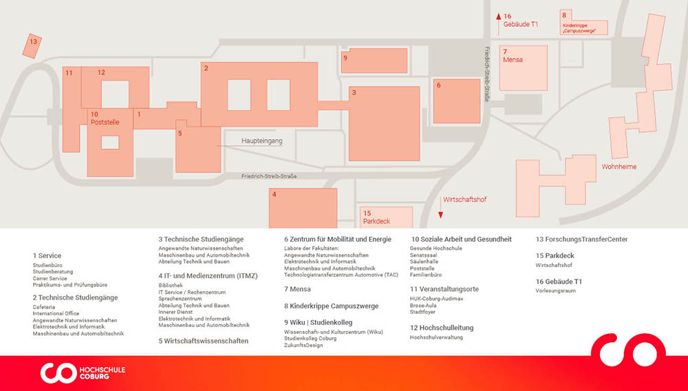
Campus Friedrich Streib
You are currently viewing a placeholder content from Google Maps. To access the actual content, click the button below. Please note that doing so will share data with third-party providers.
More InformationFrom the south: A 73 – Exit 11, Untersiemau/Coburg Süd, then continue on the B 289 and B 4 into the city area.
On the four-lane B 4, take the "Weitramsdorf" exit and follow the signs for "Hochschulen".
Parking facilities
There is a parking garage with more than 500 parking spaces on the Friedrich Streib campus.
Visitors drive up to the barrier on level 5 and can register there at the control center.
They will then open the barrier so that visitors can park in the area for employees.
Another parking lot is located in Sonneberger Straße.
From there it is about a 5-minute walk to the university. From the north: A 73 – exit 7 in the direction of B 4 (Coburg, Bad Rodach).
On the B 4, take the "Weitramsdorf" exit and follow the signs to "Hochschulen". From the west: B 303 and then B 4 towards Coburg.
On the four-lane B 4, take the "Weitramsdorf" exit and follow the "Hochschulen" signs from there. From the east: take the B 303 and then the B 4 into Coburg.
On the four-lane B 4, take the "Weitramsdorf" exit and from there follow the signs for "Hochschulen".
Verlassen Sie den Bahnhof über den Ausgang „Innenstadt". Halten Sie sich dann unmittelbar rechts. Nach ca. 200 m kommen Sie zum Busbahnhof (ZOB).
Nehmen Sie die Linie 1407 (Richtung Scheuerfeld). Steigen Sie an der Haltestelle Erfurter Straße aus. Laufen Sie 10 m zurück, überqueren Sie die Thüringer Straße und gehen Sie geradeaus in die Eisenacher Straße, die nach 150 m in die Friedrich-Streib-Straße mündet. Vorbei an der Mensa (linker Hand) kommen Sie auf das Gelände der Hochschule.
- Linie 1405 (Fahrzeit: 5 Minuten)
Die Linie 1405 (Richtung Beiersdorf) fährt ebenfalls vom Bahnhof ZOB zur Hochschule. Steigen Sie an der Haltestelle Hochschule aus. Überqueren Sie die Thüringer Straße und gehen Sie geradeaus in die Eisenacher Straße, die nach 150 m in die Friedrich-Streib-Straße mündet. Vorbei an der Mensa (linker Hand) kommen Sie auf das Gelände der Hochschule.
Duration: approx. 10 – 12 minutes From the station, walk through the pedestrian underpass to the rear exit of the station.
The steps lead you up to the footpath that runs parallel to the city highway.
Follow the footpath straight ahead until you come to the junction with "Rummental" street.
From here you have three options:
- Option 1: Cross the street "Rummental" and follow the street "Gabelsberger Straße" until you reach the university campus.
You are then at the rear entrance with the Brose-Aula. - Option 2: Follow the "Rummental" road up the hill to the "Eisenacher Straße" junction.
Turn right here into "Eisenacher Straße", which becomes Friedrich-Streib-Straße after 150 meters.
You will then be in front of the canteen and the Center for Mobility and Energy. - Option 3: Cross the "Rummental" road and continue parallel to the city highway.
After a few meters you will reach the stairs to the "Callenberger Unterführung".
Here you can take the stairs to the left until you reach Gabelsberger Straße.
This leads to the university campus.
You will then be at the rear entrance with the Brose-Aula.
Campus Design
You are currently viewing a placeholder content from Google Maps. To access the actual content, click the button below. Please note that doing so will share data with third-party providers.
More InformationFrom the south: A 73 – exit 11, Untersiemau/Coburg Süd, then continue on the B 289 and B 4 into the city area.
Take the "Co-Wüstenahorn" exit (red brick bridge).
At the end of the exit, turn left and then keep straight ahead at the traffic lights.
Then turn right into the street "Am Hofbräuhaus".
You will see the Hofbrauhaus, which is part of Campus Design, on your left. From the west: Take the B 303 and then continue on the B 4 into the city of Coburg.
Take the "Co-Wüstenahorn" exit (red brick bridge).
Turn left at the end of the exit and then keep straight ahead at the traffic lights.
Then turn right into the street "Am Hofbräuhaus".
You will see the Hofbrauhaus, which is part of Campus Design, on your left. From the east: Take the B 303 and then continue on the B 4 into the city.
Take the "Co-Wüstenahorn" exit (red brick bridge).
Turn left at the end of the exit and then keep straight ahead at the traffic lights.
Then turn right into the street "Am Hofbräuhaus".
You will see the Hofbrauhaus, which is part of Campus Design, on your left. From the north: A 73 – Exit 7 direction B 4 (Coburg, Bad Rodach).
On the B 4, take the exit "Co-Ost/Campus Design" (red brick bridge).
Turn right at the end of the exit and then keep straight ahead at the traffic lights.
Then turn right into the street "Am Hofbräuhaus".
You will see the Hofbrauhaus, which is part of Campus Design, on your left.
Parking
There are no parking spaces available on Campus Design.
Visitors can use the public parking garages in the city or the Anger parking lot.
Fahrzeit: 4 Min., Linien 1402 und 3
Verlassen Sie den Bahnhof über den Ausgang „Innenstadt". Halten Sie sich dann unmittelbar rechts. Nach ca. 200 m kommen Sie zum Busbahnhof (ZOB). Nehmen Sie hier die Linie 1402 (Richtung: Wüstenahorn) oder die Linie 1403 (Richtung Sändleinweg). Steigen Sie an der Haltestelle Hofbrauhaus aus.
Duration: approx. 20 minutes Leave the station via the "Innenstadt" exit.
Then keep immediately to the right and walk approx. 350 m along Lossaustraße.
Follow the bend to the right and cross the road before the underpass, which you will see on your right.
You will reach the street "Sonntagsanger", which you follow for approx. 750 m.
You will come to a red brick bridge.
Use the steps there to get onto the bridge.
From there you can already see the striking "Hofbrauhaus" building with its large flight of steps.
CREAPOLIS Makerspace und HTAplus Modulbau mit dem CRAI
You are currently viewing a placeholder content from Google Maps. To access the actual content, click the button below. Please note that doing so will share data with third-party providers.
More InformationAus südlicher Richtung:
A 73 – Ausfahrt 11, Untersiemau/Coburg Süd, dann weiter auf B 289 und B 4 in das Stadtgebiet fahren. Bei Ausfahrt „Co-Wüstenahorn" (rote Backsteinbrücke) abfahren. Am Ende der Abfahrt nach links abbiegen und sich dann an der Ampel rechts einordnen. Danach nach rechts fahren in die Uferstraße. Gleich wieder rechts in die Schlachthofstraße. Hier sehen Sie bereits linker Hand das Schlachthofgelände mit dem CREAPOLIS Makerspace und dem HTAplus Modulbau.
Aus westlicher Richtung:
B 303 und dann weiter auf B 4 in das Stadtgebiet Coburg fahren. Bei Ausfahrt „Co-Wüstenahorn" (rote Backsteinbrücke) abfahren. Am Ende der Abfahrt nach rechts abbiegen. Danach nach rechts fahren in die Uferstraße. Gleich wieder rechts in die Schlachthofstraße. Hier sehen Sie bereits linker Hand das Schlachthofgelände mit dem CREAPOLIS Makerspace und dem HTAplus Modulbau.
Parken
Auf dem Campus Design stehen keine Parkplätze zur Verfügung. Besucher können die öffentlichen Parkhäuser in der Stadt oder den Anger-Parkplatz nutzen.
Fahrzeit: 14 Min., Linien 1402 und 1403
Verlassen Sie den Bahnhof über den Ausgang „Innenstadt". Halten Sie sich dann unmittelbar rechts. Nach ca. 200 m kommen Sie zum Busbahnhof (ZOB). Nehmen Sie hier die Linie 1402 oder die Linie 1403. Steigen Sie an der Haltestelle Schillerplatz/SÜC aus.
Lucas Cranach Campus
You are currently viewing a placeholder content from Google Maps. To access the actual content, click the button below. Please note that doing so will share data with third-party providers.
More InformationFrom the south: Take the B 303 and then continue on the B 85 towards "Kronach-West".
Turn left at the "Stadtmitte" exit (Nordbrücke).
At the end of the exit, turn right towards "Stadtmitte".
At the next opportunity, turn right into Güterstraße.
Follow the road.
The Lucas-Cranach-Campus, where Coburg University of Applied Sciences is located, is on your left. From the west: Drive in the direction of Kronach until you reach the B 85.
Turn right in the direction of "Stadtmitte" (Nordbrücke).
At the end of the exit, follow the main road to the left.
At the next opportunity, turn right into Güterstraße.
Follow the road.
The Lucas-Cranach-Campus, which is home to Coburg University of Applied Sciences, is on the left. From the east: Take the B 303 and then the B 173.
Turn right at the "Schulzentrum" exit.
Follow the road straight ahead.
Turn left towards "Fernverkehr" and "Post Bahnhof".
Follow Schwedenstraße straight ahead and after approx. 350m turn left towards Adolf-Kolping-Straße.
Turn right at the next opportunity and then left towards Güterstraße.
Follow the road.
The Lucas-Cranach-Campus, where Coburg University of Applied Sciences is located, is on your left. From the north: Stay on the B 85 and drive in the direction of "Stadtmitte".
Turn right at the "Stadtmitte" exit (Nordbrücke).
At the end of the exit, follow the priority road to the left.
At the next opportunity, turn right into Güterstraße.
Follow the road.
The Lucas-Cranach-Campus, where Coburg University of Applied Sciences is located, is on your left.
Parking
There are several free parking facilities around the LCC for students.
From there, the campus can be reached quickly on foot. Overview of parking facilities
Duration: approx. 3 minutes Leave the station in the direction of Güterstraße to the left.
Follow the road.
The Lucas-Cranach-Campus is located on the right-hand side.
FADZ Lichtenfels
You are currently viewing a placeholder content from Google Maps. To access the actual content, click the button below. Please note that doing so will share data with third-party providers.
More InformationDirections from Coburg:
- Follow B4 take the B289 to Lichtenfels, take exit 12-Lichtenfels-Nord on A73
- Keep left and continue on B289
- On the A73 via the U12/Nürnberg/Bamberg/Lichtenfels exit
- Take exit 12-Lichtenfels-Nord in the direction of Lichtenfels-Nord/Lichtenfels-Kösten/Kloster Banz
- Take Köstener Str. and Coburger Str. to Laurenzistraße
- the FADZ is located on the right-hand side
Parking
- Parking garage Stadtgraben / Unteres Tor, Am Stadtgraben 9, 96215 Lichtenfels (approx. 5 minutes walk to the FADZ)
- Parking garage Oberes Tor, Pabstenweg 9, 96215 Lichtenfels (approx. 5 minutes walk to the FADZ)
Lichtenfels train station is approx. 5 minutes' walk from the FADZ. Public transport: Lichtenfels Marktplatz stop (approx. 1 minute walk to the FADZ), accessible with lines 1201, 1203, 1204, 1205, 1212, 1213 and 1214 Further information on timetables
Bamberg Academies
You are currently viewing a placeholder content from Google Maps. To access the actual content, click the button below. Please note that doing so will share data with third-party providers.
More InformationBy car, it is best to leave the highway at the "Bamberg" or "Bamberg-Süd" exit.
Then follow the "Berliner-Ring" and then the "Münchner-Ring".
Follow the signs to the hospital.
From Bamberg train station, bus number 901 also runs in the direction of "ZOB/Klinikum".
This will take you directly to the Bamberg Clinic.
Our building is located directly to the right of the clinic building.
If you are coming from the main entrance of the clinic, keep left after the ramp.
Follow the path straight ahead and leave the giraffe (metal figure) on your left and then the Skills Lab building behind you.
This will take you across the inner courtyard to the rear entrance of the Bamberg Academies.
You will find the premises of Coburg University of Applied Sciences on the 2nd floor.
From the bus stop, it is best to use the footpath between the Philippuskirche and the daycare center.
This will take you directly to our main entrance.
If you park behind the clinic, walk towards the Hospizverein.
You will reach the inner courtyard and the rear entrance to the Bamberg Academies via the red paved path.
Contact

Coburg University of Applied Sciences
- +49 (0)9561 317 0 (head office)
+49 (0)9561 317 275 (Fax head office)
- post office[at] hs-coburg.de (head office)
P.O. Box 1652 96406 Coburg
Overview
The website of Coburg University of Applied Sciences was translated using translation software provided by a third-party provider such as DeepL. The official text is the German version of the website. No liability is assumed, either explicitly or implicitly, for the accuracy, reliability, or correctness of the translations into another language.
